A central component of the Land Use Element is the inclusion of a diversity of land use designations to adequately classify and distinguish the various land uses needed within the county, as well as descriptions that distinguish between corresponding levels of intensity, density, and allowable uses as required by Government Code Section 65302(a)). The General Plan Land Use Diagram (see Figures 2-4 and 2-5) provides a graphical representation of the distribution of allowed land uses within the unincorporated areas of Ventura County. It gives direction for how, where, and what kind of development may occur. An overview of land use designations and their locations in the county is described and illustrated in section 3.5, “General Plan and Area Plan Land Use Designations,” of the Background Report.
Goal: LU-4
To ensure that land uses are appropriate and compatible with each other and guide development in a pattern that will minimize land use conflicts between adjacent land uses.
The County shall maintain and implement a Land Use Diagram for purposes of describing the types of allowed land uses by geographic location and the density and/or intensity of allowed uses within each designation.
The goals and locational descriptions set forth in this Element are general guidelines for determining whether land should be within a particular land use designation depicted on the General Plan Land Use Diagram (Figures 2-4 and 2-5). The land use designation applied to a specific parcel of land shall be as designated on the General Land Use Diagram, whether or not such parcel meets all of the applicable criteria.
The General Plan Land Use Diagram covers the mainland areas of the county. The following designations apply to Anacapa and San Nicholas islands and are incorporated into the Land Use Diagram by reference.
- Anacapa Island is designated “OS” as Open Space
- San Nicholas Island is designated “P” as State, Federal, Other Public Lands
It is common for the County to update the Land Use and Circulation Diagrams over time. Please check with the Planning Division of the Ventura County Resource Management Agency to ensure you have the current version.
- Recognizing the desirability of retaining existing uses and densities on the subject land;
- Recognizing the desirability of accommodating anticipated uses on the subject land;
- Maintaining continuity with neighboring zoning, land uses and parcel sizes;
- Implementing the recommendations of specific zoning and land use studies of the area in question;
- Recognizing and addressing the presence and significance of resources and hazards; and
- Evaluating the ability to provide public services and facilities.
The County shall require subdivisions of land to meet the minimum lot area requirements established by Table 2-2, by the applicable Zoning Compatibility Matrix established by the respective Area Plans, or by the applicable Existing Community land use diagrams contained in Appendix A, and by the parcel's zoning classification. Parcels smaller than the stated minimum may be allowed under the following circumstances:
- A parcel may be created for the sole purpose of transferring, by lease or sale, possession of an agricultural water well and the land around the well as may be necessary for its operation. Such parcels, and the wells they contain, shall be used for agricultural purposes only.
- Parcels for public purposes such as, but not limited to, fire, police, municipal water wells, flood control, and other public health and safety facilities.
- Affordable and elderly housing developments that are eligible for density bonuses as specified in Article 16 of the County Non-Coastal Zoning Ordinance may be granted a reduction from the minimum lot area requirements in accordance with the provisions of Article 16 or pursuant to state law.
- Parcels designated as Cultural Heritage Sites may be granted a reduction from the minimum lot area requirements in accordance with the Non-Coastal Zoning Ordinance.
- Parcels subdivided for resource conservation purposes in accordance with the conservation subdivision process established in the Ventura County Subdivision Ordinance.
- Parcels subdivided for the perpetual maintenance of biotic or wildlife habitat in accordance with California Government Code section 66418.2.
- Parcels of less than the prescribed minimum lot area may be allowed for farmworker housing complexes on land zoned Agricultural Exclusive (AE) within or adjacent to a city Sphere of Influence, provided the remaining non-farmworker housing complex parcel is a minimum of 10 acres.
Table 2-1 General Plan Land Use Designations and Zoning Compatibility Matrix
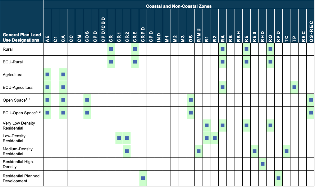

Notes: 1 The minimum lot size is 10 acres, or 20 acres if contiguous with Agricultural.
2 Parcels and corresponding zone classifications have not yet been identified for the new Parks and Recreation land use designation, Recreation zone classification or Open Space Parks and Recreation zone classification.
Table 2-2 Land Use Designation General Development Standards

* Maximum lot coverage is per appropriate County Zoning classification.
The County shall not prohibit the use or development of a parcel which is a legal lot for the purposes of the County Subdivision Ordinance, but which fails to meet the minimum lot area requirements of the applicable land use designation, solely by reason of such failure. However, this policy shall not be construed to permit the division of any parcel into two or more lots if any of the new lots fail to meet the minimum lot area requirements.
The County may grant variances to minimum lot area requirements and building intensity standards, height and setback standards applicable to a given property subject to the following conditions:
1. There are special circumstances or exceptional characteristics applicable to the subject property with regard to size, shape, topography, location, or surroundings, which do not apply generally to comparable properties in the same vicinity and land use designation;
2. Granting the requested variance will not confer a special privilege inconsistent with the limitations upon other properties in the same vicinity and land use designation;
3. Strict application of the minimum lot area requirements and building intensity standards as they apply to the subject property will result in practical difficulties or unnecessary hardships inconsistent with the general purpose of such requirements and standards; and
4. The granting of such variances will not be detrimental to the public health, safety, or general welfare, nor to the use, enjoyment or valuation of neighboring properties.
Any such variance shall be processed in the same manner and subject to the same standards as a variance respecting zoning regulations.
Goal: LU-5
To promote the effective implementation and use of the General Plan Land Use Diagram.
- maintains consistency with the General Plan Vision, Guiding Principles, and relevant goals, and policies;
- maintains consistency with the Guidelines for Orderly Development;
- minimizes the creation of a land use that is inconsistent with the policies, land uses, or development standards of surrounding parcels;
- enhances compatibility with existing or planned uses in the area;
- addresses new physical, social, or economic factors that are relevant and were not present at the time of the General Plan adoption;
- reduces the potential for undesired, growth-inducing precedent;
- demonstrates appropriate infrastructure and services are available, or amendment is conditioned on requirement to provide or appropriately fund needed infrastructure and services; and
- demonstrates acceptable effect on the fiscal health of the County.
- water courses
- ridge lines
- toes of slopes
- lines marking changes in vegetation
- lines marking changes in slope
- parcel boundaries
- roads
- rail lines
- utility corridors
- lines separating different land uses
- lines marking the separation between a group of large lots from a group of small lots
- lines marking features or designations referenced in the definitions and criteria of the various land use categories
The County shall process zone changes, if necessary, concurrently with General Plan amendments to assure zoning consistency.
1 dwelling unit per acre

Typical Uses
The land use descriptions on the following pages (both residential and non-residential) outline the range of uses that are typically found within each designation.
4 dwelling units per acre

Residential Designations
Each land use designation in this section is described in terms of typical uses and basic development standards. Development standards for land use designations suitable for residential development as the principal use (e.g., Rural, Low/Medium/High Density Residential) are based on the density of the use, as expressed by the number of dwelling units per gross acre, and the intensity of use, as expressed by a minimum lot size standard. These development standards are described on the following pages (for each residential designation) and summarized in Table 2-2. Accessory dwelling units are not included in the calculation of residential density.
The drawings to the left illustrate the concept of residential density.
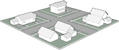
8 dwelling units per acre
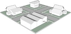
12 dwelling units per acre
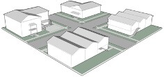
20 dwelling units per acre
Lot Coverage Examples
100% lot coverage

Non-Residential Designations
Standards of building intensity where the principle use is not residential (e.g., Agricultural, Open Space, Commercial, Industrial) development standards are based on the intensity of use, expressed as the maximum allowable lot coverage.
Lot coverage is the percent of the gross building footprint (area of the lot covered by the first floor of the building) to the net square footage of the lot. For example, a lot coverage of 100 percent will allow 10,000 square feet of gross building footprint area to be built on a lot with 10,000 net square feet of land area, regardless of the number of stories in the building. On the same lot, a lot coverage of 50 percent would allow 5,000 square feet of floor area, and a lot coverage of 25 percent would allow 2,500 square feet. These development standards are described on the following pages and summarized in Table 2-2.
The drawings to the right illustrate this concept.
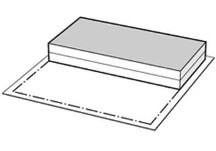
50% lot coverage
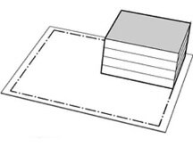
25% lot coverage
Gross versus Net Acreage Examples
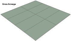
Gross versus Net Acreage (Lot Area)
The term “gross acre” includes all land within the boundaries of the lot (including, but not limited to, easements, streets, and rights-of-way) designated for a particular use. The gross acreage is defined as the total area, measured on a horizontal plane, within the lot lines of a lot. "Net lot area" means lot area less the area within any existing or proposed public or private street, road, or easement for ingress or egress, and less the area within any existing or proposed easement wherein the owner of the lot is prohibited from using the surface of the land.
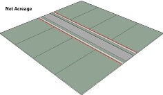
The minimum lot area for subdivision purposes is expressed in “net” area for parcels of less than 10 acres, and “gross” area for parcels of 10 acres or more.
In areas with more commercial and industrial type development, net acreage may be 20 to 25 percent less for a given site than its gross acreage. In rural areas, the difference between net and gross can be as low as 5 percent.
The drawings to the left illustrate this concept.
Ventura County contains many rural, agricultural, and open space areas that provide a variety of natural assets and resources that establish the essence of the county’s quality of life. These resources provide opportunities for residents and visitors to enjoy the county’s heritage and natural setting. The focus of this section is to provide guidance for the future of these resources in the county.
The acronym “ECU-” preceding a designation name refers to land use designations that apply only within the boundaries of an Existing Community or Urban land use designation. See Policy LU-1.2 for definition of Existing Community and Urban designated areas.
Development standards for the Rural, Agricultural, and Open Space designations are included in Tables 2-2 and 2-3 of the Land Use and Community Character Element.
RURAL LAND USE DESIGNATIONS
Rural (RUR)
The Rural designation identifies areas suitable for low-density and low-intensity land uses such as residential estates of two acres or greater lot area and other rural uses which are maintained in conjunction with agricultural and horticultural uses or in conjunction with the keeping of farm animals for recreational purposes.
The Rural designation also identifies institutional uses such as boarding and non-boarding elementary and secondary schools. Additionally, the designation is used for recreational uses such as retreats, camps, recreational vehicle parks, and campgrounds.
The designation of areas for Rural land uses is intended to accommodate the need for low density rural residential development, which, in conjunction with the higher density development of the Urban designated land uses, will provide a full range of residential environments.
The areas considered for inclusion in the Rural designation are existing clusters of rural development and areas deemed appropriate for future rural residential development.
ECU-Rural (ECU-R)
This designation provides a physical transition between the outer edges of an Existing Community or Urban Area and nearby agricultural and open space areas and uses. The ECU-Rural designation generally applies to the outer edges of Existing Community and Urban Areas and around sensitive natural resources within the boundaries of an Existing Community designated area. Typical building types include large-lot single family homes in a rural setting.
AGRICULTURAL LAND USE DESIGNATIONS
Agricultural (AG)
The Agricultural designation is applied to lands which are suitable for the cultivation of crops and the raising of livestock. Because of the inherent importance of agriculture as a land use in and of itself, agriculture is not subsumed under the Open Space land use designation, but has been assigned a separate land use designation.
Under this designation, the County shall:
- Identify, preserve, and protect agricultural lands as a non-renewable resource within the county that are critical to the maintenance of the local agricultural economy and are important to the state and nation for the production of food, fiber, and ornamentals.
- Maintain agricultural lands in lot areas which will assure that viable farming units are retained.
- Establish policies and regulations which restrict agricultural land to farming and related uses rather than other development purposes.
- Restrict the introduction of conflicting uses into farming areas.
ECU-Agricultural (ECU-A)
The ECU-Agricultural designation is applied to irrigated lands which are suitable for the cultivation of crops and the raising of livestock within the boundaries of an Existing Community designated area.
OPEN SPACE LAND USE DESIGNATIONS
Open Space (OS)
The Open Space designation encompasses land, as defined under Section 65560 of the Government Code, as any parcel or area of land or water which is essentially unimproved and devoted to an open-space use as defined in this section and which is designated on a local, regional or State open space plan as any of the following:
- Open space for the preservation of natural resources including, but not limited to, areas required for the preservation of plant and animal life, including habitat for fish and wildlife species; areas required for ecologic and other scientific study purposes; rivers, streams, bays and estuaries; and coastal beaches, lakeshores, banks of rivers and streams, and watershed lands.
- Open space used for the managed production of resources, including but not limited to, forest lands, rangeland, agricultural lands not designated agricultural; areas required for recharge of groundwater basins; bays, estuaries, marshes, rivers and streams which are important for the management of commercial fisheries; and areas containing major mineral deposits, including those in short supply.
- Open space for outdoor recreation, including but not limited to, areas of outstanding scenic, historic and cultural value; areas particularly suited for park and recreation purposes, including access to lakeshores, beaches, and rivers and streams; and areas which serve as links between major recreation and open space reservations, including utility easements, banks of rivers and streams, trails, and scenic highway corridors.
- Open space for public health and safety, including, but not limited to, areas which require special management or regulation because of hazardous or special conditions such as earthquake fault zones, unstable soil areas, flood plains, watersheds, areas presenting high fire risks, areas required for the protection of water quality and water reservoirs and areas required for the protection and enhancement of air quality.
- Open space to promote the formation and continuation of cohesive communities by defining the boundaries and by helping to prevent urban sprawl.
- Open space to promote efficient municipal services and facilities by confining urban development to defined development areas.
ECU-Open Space (ECU-OS)
This designation provides for areas with significant natural resources that should remain in open space, used for recreation, or preserved and used for resource production (e.g., mining) and are located within the boundaries of an Existing Community designated area.
Goal: LU-6
To provide appropriate land use designations that provide for the long-term preservation of the county’s rural lifestyle, productive farmland and supporting services, and the vast open space resources that define the county.
The County shall exclude structures used for growing plants such as greenhouses, hothouses, and agricultural shade/mist structures from the Agricultural land use designation maximum building lot coverage. This exclusion does not include structures used for preliminary packing, storage and preservation of produce and similar structures. Additionally, greater building lot coverage may be allowed under discretionary permits for Farmworker Housing Complexes.
The County shall exclude from the Agricultural land use maximum density farmworker
dwellings, and accessory dwelling units pursuant to section 65852.2 of the Government Code.
Additional goals and policies on agricultural resources are in Chapter 8, Agriculture Element.
Goals and policies on farm-related housing are in Chapter 3, Housing Element.
Goal: LU-7
To recognize and plan for low- density rural residential and recreational development, while preserving resources, avoiding hazards, and providing adequate public facilities and services.
Goal: LU-8
To maintain an Agricultural designation that:
Recognizes the farmlands within the county that are critical to the maintenance of the local agricultural economy and which are important to the state and nation for the production of food, fiber, and ornamentals;
Preserves and protects agricultural lands as a nonrenewable resource to assure their continued availability for the production of food, fiber, and ornamentals;
Promotes the economic viability of agricultural lands by assisting agricultural producers and establishing zoning policies that support longterm investments in agriculture;
Maintains agricultural lands in lot areas which will assure that viable farming units are retained;
Establishes policies and regulations which encourage agricultural land to remain in farming and related uses;
Restricts the introduction of conflicting uses into farming areas;
Subject to state law, the Guidelines for Orderly Development, and applicable zoning requirements, actively promotes infrastructure, sized not larger than necessary for the specific project, for farmworker housing to support the continuing viability of agriculture.
The County shall ensure that the smallest minimum lot area consistent with the Agricultural land use designation is 40 acres. The County may require larger minimum lot areas based on the zone classification.
Commercial cannabis activity shall be allowed in the County of Ventura but shall be regulated pursuant to Chapter 5 of Division 2 and Articles 5 and 7 of Chapter 1 of Division 8 of the Ventura County Ordinance Code.
Goal: LU-9
To maintain an Open Space designation that:
- Preserves for the benefit of all county residents the continued wise use of the county's renewable and nonrenewable resources by limiting the encroachment into such areas of uses which would unduly and prematurely hamper or preclude the use or appreciation of such resources;
- Acknowledges the presence of certain hazardous features which urban development should avoid for public health and safety reasons, as well as for the possible loss of public improvements in these areas and the attendant financial costs to the public;
- Retains open space lands in a non-urbanized state so as to preserve the maximum number of future land use options;
- Retains open space lands for outdoor recreational activities, parks, trails and for scenic lands;
- Defines urban areas by providing contrasting but complementary areas which should be left non-urbanized;
- Recognizes the intrinsic value of open space lands and not regard such lands as "areas waiting for urbanization”;
- Encourages Land Conservation Act (LCA) contracts on farming and grazing and open space lands; and
- Supports the productive agricultural activities of Open Space designated lands that are commonly used for agriculture, grazing, and ranching and that are important to the overall economy of Ventura County.
The County shall ensure that the smallest minimum lot area consistent with the Open Space land use category is 10 acres. The County may require larger minimum lot areas based on the zone classification.
The unincorporated county contains a wide array of housing types - from urban multifamily complexes along the coast and in some Existing Communities to rural residential uses on large acreages. The various densities of residential development in the county not only provide housing choices, but their locations and designs play a critical role in the character and quality-of-life of county residents. The focus of this section is to provide an appropriate range of residential land use designations that will guide the development of residential uses in keeping with the needs of the unincorporated county.
Development standards for the Residential designations are included in Tables 2-2 and 2-3 of the Land Use and Community Character Element.
Residential Land Use Designations
Very Low Density Residential (VLDR)
This designation provides a physical transition between the outer edges of an Existing Community or Urban Area and nearby agricultural and open space areas and uses. Typical building types include large-lot single family homes in a rural setting.
Low-Density Residential (LDR)
This designation provides for a variety of single-family homes and neighborhoods. Typical building types include small-lot single family homes, and other similar housing types, such as accessory dwelling units.
Medium-Density Residential (MDR)
This designation provides a transition from lower density, single family areas and more intensely developed
residential and commercial areas. Development at the higher end of the density allowed should occur along major
transportation routes or adjacent to commercial centers. The MDR designation generally applies to residential
neighborhoods and central areas within Existing Communities and Urban Areas.
Typical building types include one- to three-story attached single-family dwellings and lower density multifamily
developments.
Residential High Density (RHD)
This designation provides for residential development in more intensely developed residential and commercial
areas. Development at the higher end of the density allowed should occur along major transportation routes and
within major commercial centers. The RHD designation generally applies to central areas within Existing
Communities and Urban Areas.
Typical building types include one- to three-story multifamily developments.
Residential Planned Development (RPD)
The purpose of this designation is to provide areas for residential communities which will be developed using
modern land planning and unified design techniques that can be adjusted to better fit the unique needs of the
project site. Using the RPD zoning, areas with this designation provide a flexible regulatory procedure to
encourage:
- Compatibility with existing or potential development of surrounding areas;
- An efficient use of land particularly through the clustering of dwelling units and the preservation of the
- natural features of sites;
- Variety and innovation in site design, density and housing unit options, including garden apartments,
- townhouses, co-housing developments, and single-family dwellings;
- Lower housing costs through the reduction of street and utility networks; and
- A more varied, attractive and energy-efficient living environment as well as greater opportunities for
- recreation.
Coastal Residential Planned Development (CRPD)
The purpose of this designation is to provide areas for residential communities which will be developed using innovative site planning techniques. The CRPD designation generally applies to areas appropriate for modern residential development within the boundaries of an Existing Community designated area in the coastal zone.
Residential Beach (RB)
This designation provides for small-lot, beach-oriented residential communities. The RB designation generally applies to areas appropriate for high-density residential development within the boundaries of an Existing Community designated area in the Coastal Zone.
Goal: LU-10
To provide opportunities for a variety of residential types and densities in established Existing Communities, Urban areas, within a city’s adopted Sphere of Influence, and Area Plans.
The County shall ensure that the maximum building lot coverage for lots of less than one acre (nonconforming) in area shall be as specified for the Residential designation, or 2,500 square feet plus 1 square foot for each 4.596 square feet of lot area over 5,000 square feet, whichever is greater.
To support the needs of the county’s residents and visitors, a balanced set of commercial and industrial
designations is needed. The industrial designation provides appropriate areas to provide employment, products processing, and warehousing. The mixed use and commercial designations provide an appropriate mix of commercial services designed to meet the everyday needs of the community.
Development standards for the Mixed Use, Commercial and Industrial designations are included in Tables 2-2 and 2-3 of the Land Use and Community Character Element.
Mixed Use Land Use Designation
Mixed Use (MU)
This designation provides for the development of activity centers that contain a mix of compatible and integrated commercial, office, residential, civic, and/or recreational uses.
The Mixed-Use designation is only allowed within areas designated as Existing Community, Urban areas, or Unincorporated Urban Centers under Policy LU-1.2. Areas designated as MU should be of a size sufficient to promote the economic success of future developments. Developments should be located on an arterial or higher roadway classification and shall include appropriate pedestrian and bicycle facilities. Typical building types include one- to three-story horizontal or vertical mixed-use structures. Development in the MU areas can have a mix of both residential and commercial uses, or a variety of commercial uses.
Commercial Land Use Designations
Commercial (C)
This designation provides for a mix of retail and service uses that are typically needed by residents in rural
communities and surrounding agricultural operations. The Commercial designation is only allowed in areas designated as Existing Community, Urban areas, or Unincorporated Urban Centers under Policy LU-1.2. Developments in Commercial designated areas may include a mix of uses Developments should be located on a County-defined Minor Collector or higher classification roadway (as shown on Figure 4-3 or 4-4) and should include pedestrian and bicycle facilities. Typical building types include one- to two-story commercial structures.
Commercial Planned Development (CPD)
The purpose of this designation is to provide areas for vibrant commercial centers which will be developed utilizing modern land planning and unified design techniques that can be adjusted to better fit the unique needs of the project site. Using the CPD zoning, areas with this designation provide a flexible regulatory procedure in order to encourage the development of coordinated, innovative, and efficient commercial sites and to provide areas for a wide range of commercial retail and business uses, including stores, shops, and offices supplying commodities or performing services for the surrounding community.
The CPD designation is only allowed in areas designated as Existing Community, Urban areas, or Unincorporated Urban Centers under Policy LU-1.2.
Industrial Land Use Designation
Industrial (I)
This designation provides for a range of industrial employment-generating uses, including production, assembly, warehousing, and distribution, that are conducted within enclosed buildings or in appropriately sited and screened outdoor work spaces that are designed for compatibility with surrounding land uses. The Industrial designation should be limited to areas served by, or planned to be served by, public water, wastewater, and drainage systems. Developments must be located on a County-defined Minor Arterial or higher classification roadway (as shown on Figure 4-3 or 4-4).
Goal: LU-11
To promote the development of mixed-use, commercial, and industrial uses in areas that are appropriate for these uses.
This designation is applied to extensive areas of the county where good conservation practices and interagency coordination are imperative. This designation identifies and geographically locates resource areas of the county for their conservation, development, and utilization. These areas are characterized by minimal development and the limited availability of public services.
Development standards for the State, Federal, Other Public Lands designation is included in Tables 2-2 and 2-3 of the Land Use and Community Character Element.
State, Federal, Other Public Lands Land Use Designation
State, Federal, Other Public Lands (P)
This designation applies to those state- and federally-owned parks, forests, rangelands, coastal resources, and/or recreation areas. For state land within the coastal zone, the County has land use authority except for land under the California Coastal Commission’s jurisdiction (i.e., beaches and tidelands). For all other areas the County has no land use authority. Areas so designated include land under federal or state ownership on which governmental facilities are located.
Principal uses of these areas include: continued provision of public recreational facilities and access; multi-use management where applicable; support for rangeland activities, and interconnection or coordination of state, federal, and local facilities and programs when possible.
Goal: LU-12
Repealed
Goal: LU-13
To maintain a designation that:
- Recognizes lands devoted to governmental uses which are under the authority of the state or federal government and over which the County has no effective land use jurisdiction.
- Encourages the proper planning of governmental lands so that uses on these lands are compatible with existing and planned uses on adjacent privately-owned lands.
Goal: LU-14
To acknowledge the interests of cities and recognize the Ventura Local Agency Formation Commission (LAFCo) adopted Spheres of Influence as areas in which urbanization will likely occur under the authority of each city.
The County shall encourage applicants for General Plan amendments, zone changes, and discretionary development within a city’s Sphere of Influence to consult with the appropriate city about submitting their application and shall discourage applicants from applying to the County.
Additional policies on intergovernmental coordination are in Section 2.7, Development Review and Inter-Agency Coordination.
