The County shall process zone changes, if necessary, concurrently with General Plan amendments to assure zoning consistency.
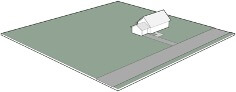
1 dwelling unit per acre
Typical Uses
The land use descriptions on the following pages (both residential and non-residential) outline the range of uses that are typically found within each designation.
4 dwelling units per acre

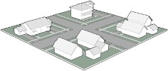
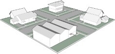
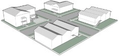
Residential Designations
Each land use designation in this section is described in terms of typical uses and basic development standards. Development standards for land use designations suitable for residential development as the principal use (e.g., Rural, Low/Medium/High Density Residential) are based on the density of the use, as expressed by the number of dwelling units per gross acre, and the intensity of use, as expressed by a minimum lot size standard. These development standards are described on the following pages (for each residential designation) and summarized in Table 2-2. Accessory dwelling units are not included in the calculation of residential density.
The drawings to the left illustrate the concept of residential density.
8 dwelling units per acre
12 dwelling units per acre
20 dwelling units per acre
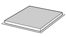
Lot Coverage Examples
100% lot coverage
Non-Residential Designations
Standards of building intensity where the principle use is not residential (e.g., Agricultural, Open Space, Commercial, Industrial) development standards are based on the intensity of use, expressed as the maximum allowable lot coverage.
Lot coverage is the percent of the gross building footprint (area of the lot covered by the first floor of the building) to the net square footage of the lot. For example, a lot coverage of 100 percent will allow 10,000 square feet of gross building footprint area to be built on a lot with 10,000 net square feet of land area, regardless of the number of stories in the building. On the same lot, a lot coverage of 50 percent would allow 5,000 square feet of floor area, and a lot coverage of 25 percent would allow 2,500 square feet. These development standards are described on the following pages and summarized in Table 2-2.
The drawings to the right illustrate this concept.
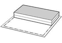
50% lot coverage
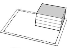
25% lot coverage
Gross versus Net Acreage Examples
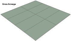
Gross versus Net Acreage (Lot Area)
The term “gross acre” includes all land within the boundaries of the lot (including, but not limited to, easements, streets, and rights-of-way) designated for a particular use. The gross acreage is defined as the total area, measured on a horizontal plane, within the lot lines of a lot. “Net lot area” means lot area less the area within any existing or proposed public or private street, road, or easement for ingress or egress, and less the area within any existing or proposed easement wherein the owner of the lot is prohibited from using the surface of the land.
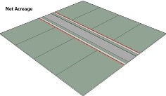
The minimum lot area for subdivision purposes is expressed in “net” area for parcels of less than 10 acres, and “gross” area for parcels of 10 acres or more.
In areas with more commercial and industrial type development, net acreage may be 20 to 25 percent less for a given site than its gross acreage. In rural areas, the difference between net and gross can be as low as 5 percent.
The drawings to the left illustrate this concept.